Published March 30, 2024 7:52am EDT
As the storm center pushes south off the coast toward the Los Angeles Basin on Saturday, it has tapped into some tropical moisture, transitioning into a brief atmospheric river storm. Its heavy rainfall has triggered flash flooding potential through the Easter holiday weekend.
By Scott SistekSource FOX Weather
Heavy rains trigger Flash Flood Warnings in Los Angeles area
A strong low pressure center swirling off the California coast is sending waves of rain into the Los Angeles and San Diego areas, triggering flooding concerns.
LOS ANGELES – Millions in the Los Angeles area were under Flash Flood Warnings early Saturday morning as the latest in a string of rainstorms again soaked Southern California.
A strong area of low pressure continues to swirl off the Central California coast, peppering much of the state with moderate to heavy showers and mountain snow. As the storm center moved south just off the coast toward the Los Angeles Basin on Saturday, it tapped into some tropical moisture, transitioning into a brief atmospheric river storm. Its heavy rainfall has triggered flash flooding potential through the Easter holiday weekend.
DOWNLOAD THE APP
 Current satellite/radar loop
(FOX Weather)
A Flash Flood Warning is in effect for the heart of the Los Angeles metro area, covering over 5.5 million people, through at least 8 a.m. PT. Heavy rains totaling between 0.75 and 1.50 inches of rain have already fallen, with rain gauges indicating additional rainfall rates of 0.5 to 1.0 inches per hour are occurring as the storm pours in.
“Flash flooding and landslides are expected,” the National Weather Service in Los Angeles warned. Similar stormy conditions led to an additional Flash Flood Warning for Santa Barbara County early Saturday morning.
Los Angeles’ LAX Airport reported 0.81 inches of rain in one hour between 3-4 a.m. and 1.39 inches total in the storm so far, with more rain expected throughout the day.
CALIFORNIA’S ‘ARKSTORM’: HISTORIC 1000-YEAR FLOODS OF 1861-62 FEATURED 8 WEEKS OF ATMOSPHERIC RIVERS
In addition, a brief Tornado Warning was issued for Santa Barbara County just before 1:30 a.m. after Doppler Radar indicated rotation in a passing thunderstorm. It was canceled 19 minutes later when the storm dissipated without reports of any tornado formation.
As much as 1.5-3 inches of rain is likely up and down coastal Southern California, including the Los Angeles Basin and San Diego area. Higher totals of 3-6 inches are likely in the foothills and mountains.
 The rainfall outlook for the Los Angeles area through Monday.
(FOX Weather)
“You’re talking a lot of rain here, and you’re working up against these mountain faces that allow a ton of rain to wring out over Southern California,” FOX Weather Meteorologist Britta Merwin said.
Throughout the weekend, much of Southern California remains under a Flood Watch, covering nearly 22 million people.
 Flood Watches for Southern California.
(FOX Weather)
Rainfall rates are forecast to reach 0.25-0.50 inches per hour across the region, with up to 0.75-1.0 inches per hour possible in locally heavier downpours and thunderstorms.
NOAA’s Weather Prediction Center has placed many urban areas in South California in a Level 2 out of 4 risk for flash flooding.
“I would be prepared for it,” Merwin said. “I don’t think it’s a question of ‘if’ we will flood, but ‘where’ we will flood. Be very cognizant of what’s going on.”
 The flash flood outlook for Southern California on Saturday.
(FOX Weather)
“Make sure you are listening to the sights and sounds around you as we have a concern about not just flooding but we start to loosen up those soils, and there is concern for landslides,” said FOX Weather Meteorologist Jane Minar. “Not only as we go through the rain (Saturday) morning, but throughout the day and throughout the weekend”
The timing of the storm couldn’t be worse for those hoping to take part in traditional outdoor Easter activities. Easter egg hunts in Pasadena, Huntington Beach and Santa Anita were either canceled or postponed to a later weekend in April due to threat of heavy rain.
Northern California is not spared from heavy rain
The storm already has a history of soaking Northern California.
Steady rain tallied about a half inch Friday in the San Francisco Bay Area, with gusty winds reaching as high as 40-50 mph, though a station along the central coast registered a gust of 62 mph during a passing thunderstorm.
Farther inland, about 15,000 customers lost power in San Jouaqin County, according to poweroutage.us.
In Central California, the Pacific Coast Highway, also known as Highway 1, is closed at the San Luis Obispo/Monterey County line at Ragged Point due to slide activity north of that location, according to CalTrans.
More showers will keep the region dodging the raindrops on Saturday.
Strong thunderstorms keep the active weather going into Sunday
The bulk of the steady, moderate-to-heavy rains will roll through Southern California on Saturday with the storm’s cold front. But once the front passes, the atmosphere will become unstable as cold air aloft moves into the region.
That will trigger possible thunderstorms on Saturday night into Sunday, with even a low chance of severe weather, including torrential downpours, quarter-sized hail, strong wind gusts and even the possibility of a weak tornado or waterspout.
 Saturday Future Cast
(FOX Weather)
“This is the classic setup where we can see isolated severe weather for Southern California,” Merwin said. “That cold air present (aloft) is going to bring in a risk of thunderstorms … We shouldn’t be shocked if we see some hail.”
WHAT IS AN ATMOSPHERIC RIVER?
Rockslides and mudslides, which have been a recurring problem throughout the soggy winter, remain possible as the ground remains saturated. Downtown Los Angeles has had nearly double its average rainfall since the start of the year, and February was among the top 10 wettest on record.
Winds will gust to 20-40 mph, with some isolated gusts to 45-60 mph over the Santa Lucia Mountains, where a High Wind Watches and Warnings remains in effect Friday.
 Wind Alerts for Southern California on Friday.
(FOX Weather)
Higher elevations to get another heavy coating of snow
“Nothing says spring like snow and blowing snow in the mountains,” the NWS in Los Angeles said Wednesday.
Heavy snow will fall in the higher elevations of the Southern California mountains this weekend, with 2-6 inches likely above 4,500 feet and 12-24 inches likely above 6,500 feet. There is even a low chance of snow along Interstate 5’s Tejon Pass in the Grapevine.
“Traveling up and down from the mountains — both in the Sierra and also the Southern California mountains, it is not going to be fun,” Merwin said. “And of course, this is the weekend that you want to do it. So be smart and be safe.”
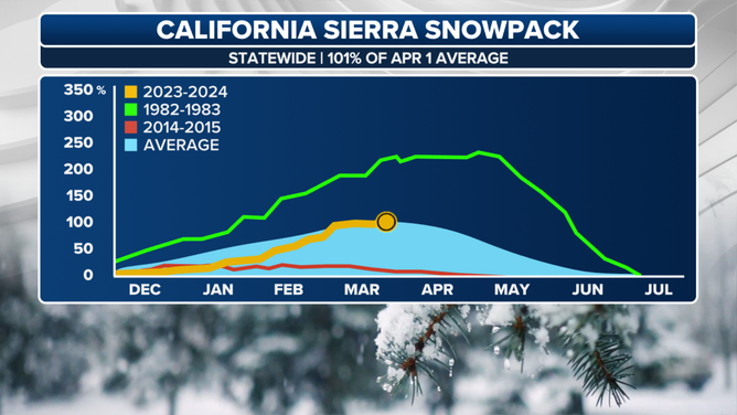
Statewide chart showing recovery of snowpack in California this year.
(FOX Weather)
Snow will also pile up in the Sierra Nevada, where a few feet of snow will add to the snowpack now sitting at 101% of the average statewide.


